
Aerial data collection reaches places that ground teams can't, covers large areas quickly, and gives decision-makers real-time information they can't get any other way. Drones have made that access cheaper and more flexible, and adoption has grown accordingly, bringing with it large volumes of data. That volume can quickly become a disadvantage, leading to overwhelm and inefficiency. An intelligence framework provides the structure needed to turn this data into something a decision-maker can act on.
The first two articles in this series covered the decision gap that opens when organisations invest in collection without that framework and then examined the intelligence cycle that closes it. This third article looks at Precision Aerial Intelligence, the intelligence framework we apply to aerial collection.
Aerial platforms are collection tools
Organisations that invest in aerial programs are usually trying to fix something, whether it's a maintenance backlog, a security gap, or a slow planning cycle. Drones have made aerial collection cheaper and more accessible than ever, often resulting in the platform being bought before a collection plan, or even a requirements analysis, is carried out. A drone, or any aerial platform, is a tool for collecting data, which is then processed through data analysis software. That combination can process what's collected, but it doesn't decide what should be collected and why in the first place, and it doesn't guarantee the result is shaped for the person who will act on it.
The benefits organisations are chasing, such as more frequent inspections, faster situational awareness, earlier detection of emerging issues, or more consistent data over time, depend on deciding what to collect and why, and on shaping the result for the person who will act on it. The most effective way to do this is with an intelligence framework, which needs to be developed before a flight plan is written, if not before the collection platforms are decided. We call this Precision Aerial Intelligence.
What is Precision Aerial Intelligence?
Precision Aerial Intelligence (PAI) is the intelligence cycle applied to aerial collection. The same five stages from the previous article apply here: direction, collection, processing, analysis, and dissemination.
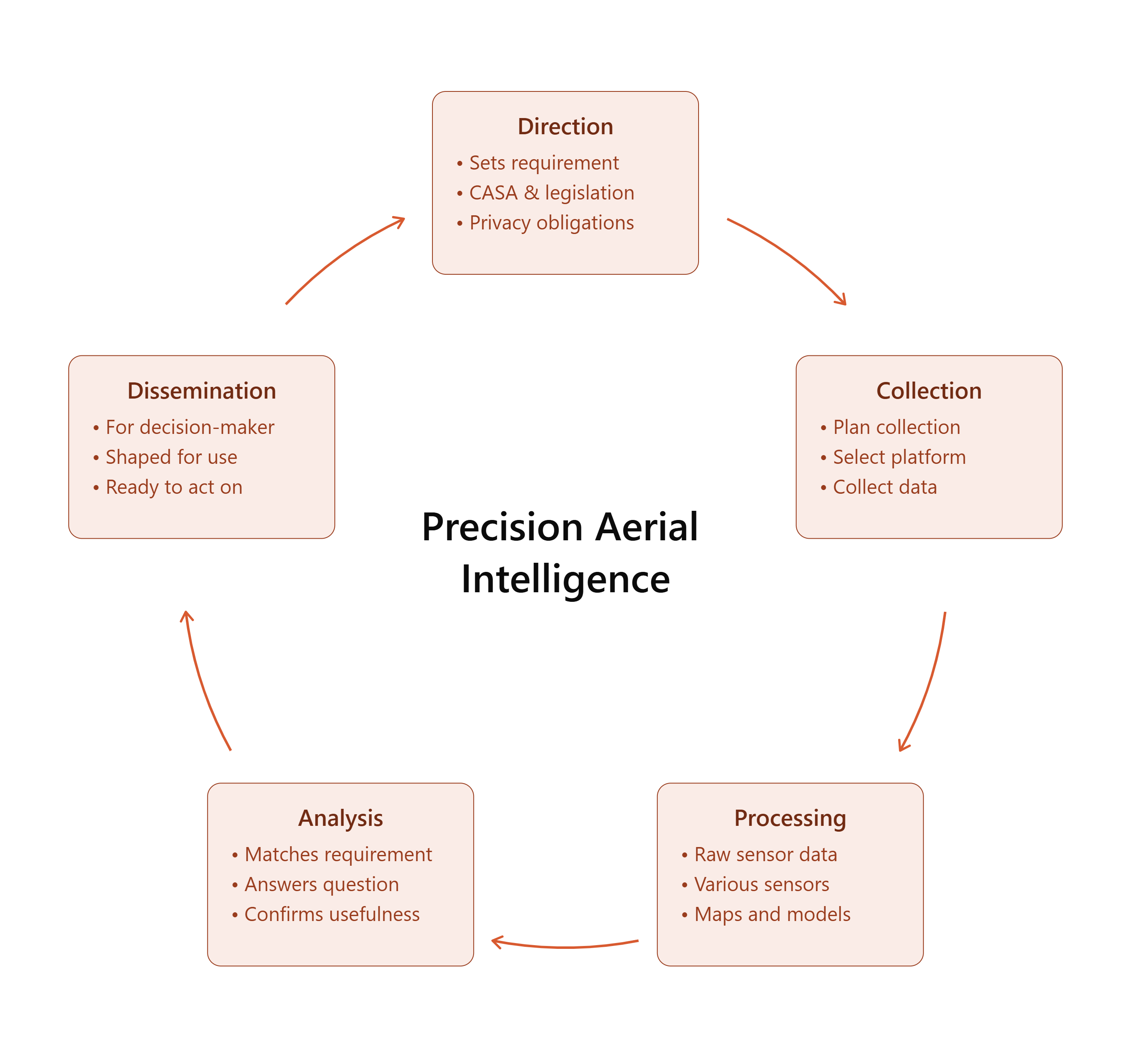
Direction sets the requirements, what needs to be known, and why, before a platform is chosen or applied to one already in use. This is also where legal and ethical parameters are established, what the collection is authorised to capture, under sector-specific legislation, and privacy obligations that vary by what's being collected and where.
Collection starts with a plan, which determines what information is needed, what sources can provide it, and what constraints, such as time, access, weather, or airspace, might affect it. If a platform and sensor combination hasn't been chosen yet, it's selected to fit the requirements, whether that’s an uncrewed aircraft, a crewed platform, or another aerial source, depending on the task. If one's already in use, the same requirements determine whether it's fit for purpose, and what additional capability is needed if it falls short. The platform then collects against that plan.
Processing converts raw sensor data, imagery, thermal, multispectral, or LiDAR, into maps, models, or other outputs ready for analysis.
Analysis interprets what's been processed against the original requirements, answering the specific questions the decision-maker needed answered.
Dissemination delivers the finished product to the decision-maker who will act on it, shaped for how they'll use it.
The following two examples show where this cycle would make the biggest difference.
Example 1: Infrastructure and asset operations
Consider a large renewable energy operator managing a portfolio of solar and wind assets across multiple sites. Aircraft are already part of the maintenance program, and imagery is collected on a routine inspection schedule.
The inspection schedule follows site access and aircraft availability. Thermal anomalies on solar panels and blade surface conditions on wind turbines already feed into replacement timelines, warranty claims, and capital planning cycles. Findings from every site across the portfolio move through that process in roughly the order they're reviewed. There's no triage system establishing which issues need immediate action and which can wait. The inspection program also wasn't designed to flag when monitoring capacity itself falls short. For example, a growing portfolio outpacing the current collection frequency only becomes visible after coverage has already fallen behind, and by then the maintenance backlog is more expensive and harder to plan around.
Applying PAI here starts with direction, defining the asset decisions that carry the most consequence. What does the maintenance team need to know to prioritise effectively across a dispersed portfolio, and what threshold separates immediate action from scheduled intervention? Are the current collection frequency and monitoring capacity sufficient to catch emerging issues before they escalate, or does the portfolio's growth mean that capacity needs to be resourced in advance? What resolution, collection frequency, and sensor type is required to answer those questions, and is the current program delivering it?
Understanding the direction changes how findings are worked and, where needed, how often collection happens. Findings are triaged against defined thresholds rather than reviewed in the order they arrive, and monitoring capacity is assessed against portfolio growth rather than only becoming visible once it's fallen behind. The result is conclusions the capital planning committee can act on with confidence.
Example 2: Land management and biosecurity
This example draws on publicly available data about the NSW Government's feral pig and deer management program, illustrating where this framework would have the greatest effect.
Feral pigs and deer cause significant damage to agriculture, native vegetation, and waterways across NSW. The state government's coordinated response has removed almost 250,000 feral animals over the past three years, with single operations covering more than 149,000 hectares across mixed land tenures.[1]
Feral animals move across large, complex landscapes that cross property boundaries, and no single collection platform can survey that ground efficiently. Current programs rely on landholder reporting and ground-based camera networks to build a picture of where animals are, but that picture doesn't extend to the landscape-scale distribution needed to plan an operation. Aerial shooting resources, costing around $1,200 per helicopter hour, are committed against that limited picture, without a way to confirm the locations and sequence that would reduce animal numbers the most for the money spent.[2]
Applying PAI here starts with defining what coordinators need to know to commit resources where they'll have the greatest effect. Satellite imagery then defines the problem at a landscape scale across multiple land tenures, looking for signs of animal activity, vegetation damage, wallows, and trails, and tracking how those signs cluster around habitat and water sources over time to identify areas of interest. Targeted drone collection with thermal and multispectral sensors builds the detailed picture those areas require. Thermal sensors detect animals by their body heat, most effective at dawn and dusk when feral pigs and deer are most active, while multispectral imagery picks up vegetation stress patterns that indicate recent feeding activity. Analysis identifies where the animals are, where they're moving, and where to commit the helicopter first.
Coordinators can sequence operations where animal density is highest, based on satellite and drone data, so helicopter hours go to locations most likely to reduce numbers, rather than to areas that happened to generate the most landholder reports. That sequencing also creates a record of why resources went where they did, useful when program funding depends on demonstrating results to funders and land managers.
Whether the platform's already in place or yet to be chosen, the starting point for working with us looks different for every organisation.
How we work with you
There's no fixed entry point for a Precision Aerial Intelligence engagement. We start with a quick assessment to understand where you are, what requirements you're trying to support, what collection capability you already have, and where the shortfall is.
The engagement takes the shape that fits your situation.
Some clients need us to run the full program. We design the intelligence cycle, select or source the platform, conduct the flights, produce the intelligence, and deliver a product the decision-maker can act on.
Others already have aerial programs and capable teams in place. They need the intelligence cycle built around what they're already doing.
Others want to build the capability in-house. We design the cycle, train the team, and set them up to run it themselves.
A single engagement can support a specific requirement. An ongoing arrangement keeps the intelligence cycle running across a program or an operational season.
Let’s Talk
If your organisation is collecting, or planning to collect, aerial data without knowing your requirements, or isn't sure whether the collection meets them, the framework beneath the platform is the place to start.
The right starting point is a conversation about requirements, what your team needs to know, and whether your current collection program is built to deliver it.
If you'd like to understand the methodology behind it, the first two articles in this series are a good place to begin:
- The Decision Gap: Why better technology is not producing better decisions
- Intelligence for Everyone: A five-stage process for high-stakes decisions
Get in touch to discuss how our Precision Aerial Intelligence framework can help.
Fire Hawk Services
admin@firehawkservices.com.au
Making better decisions when it matters most
Publication Note: AI tools were used to assist with researching, structuring and editing for clarity. All views expressed are those of the author(s).
Sources
National Feral Pig Action Plan. (n.d.). https://www.feralpigs.com.au/nsw
NSW Department of Primary Industries and Regional Development. (2026). Government moves to make feral pig and deer management bigger and better as nearly 250k pigs culled over past three years. https://www.dpird.nsw.gov.au
[1] NSW DPIRD (2026)
[2] National Feral Pig Action Plan (n.d.)